 |
| Turnagain Arm (photo by author) |
 Consists of all the frozen places on the Earth. It is seasonal and can increase and decrease with Earth’s revolution around the Sun.
It’s made up of: Snow
Ice
Sea Ice
Glaciers
Ice shelves
Icebergs
Frozen ground. (Permafrost...)
Locations of the world include the North and South Pole (Arctic and Antarctica), mountain regions, and the northern climates of Russia, U.S. and Canada.
Looking for maps and an atlas?
 |
| photo from http://nsidc.org/ |
Still not impressed? Watch a movie from NASA.
Other great current images can be found at The Cryosphere Today website.
For my own background, I found a website that dealt with actual research on the Cryosphere. I found papers on the Greenland freshwater runoff to measuring albedo in the Himalayan Basin. Yes, a little over my head but fascinating for a science teacher.
From viewing the TD videos, we saw how the Arctic climate influences those that lived there, so I wanted to find out some specific changes to the ice and snow cover and their effect on the indigenous people of Southern Greenland.
I went to the INUIT Circumpolar Council website and found a publication that listed some of the changes local people have noticed due to the changing climate of Greenland.
- Many mentioned that local glaciers were receding- so much so that the landmarks naming these glaciers were no longer correct!
- Because of less snow cover, berries such as the Crowberry have become scarce.
- Ice cover on the beaches has all but disappeared in the winter, thus moving animals to different areas and making traveling on ice dangerous.
- The native people of Southern Greenland also have seen an increase of algae on the skin of seals and their boats.
- (An interesting observation I have also noticed here in South-central. My roof is covered in moss and algae as is the north sides of the cottonwoods around my house. More so than any other year.)
Permafrost has always facinated me and seasonal frozen ground has always been a struggle especially when digging the biannual outhouse hole out at camp.....
 |
| photo from the virtual tunnel tour http://permafrosttunnel.crrel.usace.army.mil/ |
Evaluate
I am looking into using vernier probes more in the classroom , (I just wish I had newer laptops). The activity looking at white and black paper and how they might influence the temperature of a liquid could easily be modified using temperature probes.
Beginning of the year scientific method activities using probes and the concept of albedo would make for some exciting discoveries for new eighth graders. Comparing the reflected light of different surfaces would allow my students a great hands on activity for exploring this concept.
The TD diagram on Arctic Sea Ice Observation would also let students use data to compare the area and square kilometers of the ice pack for the past ten years. STEM should be all over this.
The tour of the Cryosphere was one of the best tools for students to see the different locations and extent of the Earth's frozen areas. I couldn't believe how fast the Jakobshavin Glacier was moving! 5 feet an hour! I have grown up watching Portage Glacier move farther and farther back, and I certainly can relate to what the Greenlanders must be going through.
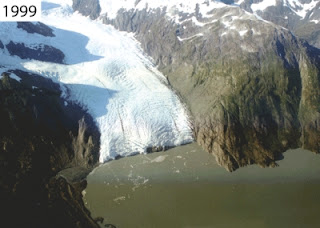
Here are some photos from the Portage Glacier USGS site (see above) that shows the receding glacier from when I was seven years old, to graduating from high school, to the year I became a full time teacher in Anchorage.
 | |||||||
| 1972, USGS photograph; 1984, Aeromap U.S.; 1999 and 2006, USGS photographs. |
This module about the cryosphere was very interesting to me. Not only for the educational tools but the wealth of information about the science out there about my favorite season of the year. I can't wait to enjoy that frozen water on my skis in the Chugach mountains behind my house. Sunglasses in March? I blame the albedo....
Comments
Doug had a great module this week. I found a book recommendation for Wohlforth's The Whale and the Supercomputer.
Marilyn lead me to the National Ice Center, where I found links for .kmz files for my new passion: Google Earth.
Clay was right on about Lila's site. I found it interesting and full of relevant science.


I like the pictures that you had to offer. I really enjoyed the beginning when you explained cryosphere. This was a new term for me and you really seem to explain it step by step here. The permafrost tunnel in Fairbanks also sounds very interesting and is something I would like to learn more about.
ReplyDeleteI lived in Fairbanks for five years while going to college & never knew about this tunnel! How cool to have toured it. I’m jealous of you, Konrad!
ReplyDeleteKonrad,
ReplyDeleteThanks for the link to the permafrost tunnel in Fairbanks. That's particularly relevant to Module IX, as well. I also was impressed by the shots of the portage glacier.
This is a great post. I especially like the cyrosphere atlas and the Inuit Circumpolar Council website. It would be fun to have the students explore the observations on this site! Also, I did not know about the permafrost tunnel in Fairbanks. I’d like to take that tour!
ReplyDeleteGreat pictures! I especially like the one of the iceberg. It is always amazing to me when you see the amount of ice under the water. As they say, it is only the tip of the iceberg!
ReplyDeleteWow, that tunnel looks amazing!
ReplyDelete