Introduction
Making connections between two major branches of science when teaching middle school can be a challenge. Making these connections helps students link their lives to everyday science and its phenomena.
 |
| Starry Night software program. The sky looking North at 20:37 Dec 29th from Indian, AK |
Before starting a unit on chemistry, I make sure I end my Astronomy unit with stars and constellations of the Northern sky. The study of stars is a great place to introduce elements and the chemical interactions that make up the 8th grade curriculum.
 | |
| This is a photo taken by the X-Ray Telescope (NASA) of an exploding star |
Background
The light radiating from the stars in the sky can be visible and invisible to the naked eye. This energy is known as electromagnetic radiation.
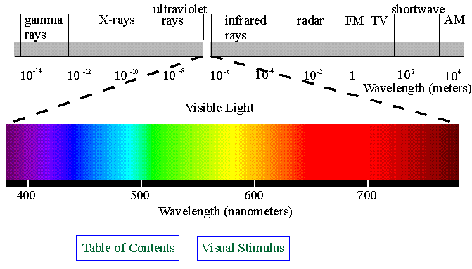 |
| The Electromagnetic Spectrum. Graphic from http://www.kollewin.com/blog/electromagnetic-spectrum/ |
The light we can see is only one type of electromagnetic radiation. Stars can give off radiation you can’t see such as radio or ultraviolet light.
Electromagnetic radiation can be broken into ranges based on the size of their wavelength. All of the different types of electromagnetic waves make up the electromagnetic spectrum.
Light will travel in waves and those waves have troughs and peaks that are long or short depending on the energy. This spectrum can tell astronomers the temperature and even the composition of the stars.
Astronomers not only use visible light telescopes but radio and x ray telescopes to capture and analyze the energy from distance stars.
 |
| http://www.pa.uky.edu/sciworks/physicspettingzoo/Spectroscope.htm |
Astronomers use a tool called a spectroscope to capture visible light and break it into a spectrum that can be analyzed for the presence of different elements.
 | |
| http://webmineral.com/help/FlameTest.shtml |
As you can see from the spectrogaph, each element has a specific wavelength, or fingerprint, of light. Most light (visible), can be separated into component wavelengths. This separation is from the spectroscope’s prisms or diffraction grating. Of the three types of spectra: continuous, emission, and absorption, the last two can be used as “fingerprints” in the identification of elements.
Each element in its gaseous form will give off light in definite wavelengths. Elements and compounds can be identified by the light they absorb through bright lines in the spectrum. These are measured in Angstroms, through the Spectroscope (see example).
The lab
Flame Test, Spectroscopes, and Stars
 |
| Photo by author |
Question: How can we determine the metals in certain solutions?
Purpose: To understand that metals lose energy in the form of light and this light can be broken up into a spectrum resulting in different wavelengths that can be analyzed into a known line spectrum of different elements.
Materials:
- Bunsen Burner
- Test Tubes (6)
- Test tube rack
- Goggles
- Nichrome wire
- 5 metal solutions
- HCl solution
- distilled water
- spectroscope
Procedure: 1. Label the test tubes A – E
2. Pour 5ml of from each of the labeled solutions into corresponding labeled test tube.
3. Clean the nichrome wire by dipping it into the HCl solution provided to you and then the distilled water and drying it in the Bunsen burner. Repeat until the wire doesn’t color the flame form the Bunsen burner.
4. Dip the clean wire into one of the labeled test tubes solutions. Hold the wire at the inner cone of the flame. Record color and any other observations in the data table.
5. Using the spectroscope, find the metal’s spectrum by looking at the flame. Look for any dark lines and note what color they are in.
6. Diagram your spectrum or use the textbook (page 100, Fig 4) to find the element’s line spectrum.
7. Repeat steps 2-4 for the other chloride solutions.
8. Please rinse out all test tubes and clean your area.
Data:
Test Tube | Color | Solution |
A | ||
B | ||
C | ||
D | ||
E |
Conclusions: If your test solution was a mixture of two metal ions, could you identify both? Try it. Try the spectroscope and see if you can see two different lines.
 |
| Photo by author |
Questions
1. What is a spectrum? How is a spectrogram useful in studying stars?
2. Why is it necessary to clean the wire between each test?
3. Some flame tests were very apparent in the color produced while others were more vague. What do you think are some reasons that could account for this?
4. How do the samples resemble stars? How can scientists tell what elements are in a distant star?
5. Diagram the Bunsen Burner equipment and show a correct flame. Label all parts. Color is an option.
Enrichment
The lab is a fun way to explore why stars give off light in different colors and a lot of students feel they are doing "real" science. The problem is sometimes its hard to see through the spectroscopes and see any prisms especially the lines. Other labs use different types of lamps and lights to find known elements and using one of these would be a great demonstration or lab on its own.
The Discovery video collections have great videos as we well know. My favorites are the ones we have already used in this class and I plan on using them in mine!
Another video that gets the kids excited about chemistry is KABOOM!. The interaction of different elements makes for cool chemistry.
The Discovery video collections have great videos as we well know. My favorites are the ones we have already used in this class and I plan on using them in mine!
Another video that gets the kids excited about chemistry is KABOOM!. The interaction of different elements makes for cool chemistry.
 |
| http://www.teachersource.com/Chemistry/ChemistryResources/KABOOM_NovaVideo.aspx |
Cultural connection
There are many stories about the stars and the patterns they make in the sky. Ancient Greek and Roman stories abound. But other cultures have stories that would interest most middle school students. The Alaskan natives for example have several stories of the strange lights that appear in the sky. These stories can be used as introductory lessons to get the students thinking about the constellations and a spark for their imagination in making up their own stories of the stars.
I especially love the stories of the Northern Lights and have heard several versions of the gods in the sky playing kickball with a skull. Many elders I have known are still afraid of the
Aurora.
The state flag of Alaska is also a great introduction of the night sky and connections to Native Alaskans.
Conclusions
I have done the flame test lab several times as a demo and as a real lab. By using the new resources on the web and our own video library at Discover, I think this lab activity will help middle school students grasp the connection between the different branches of science and allow them to make these connections on their own through life long learning.
Please feel free to email me to get the word flame test document and feel free to use it and modify it for your classroom. mittelstadt_konrad@asdk12.org
Its been a great class have a great New Years........
References
Pasachoff, J. M., Astronomy Prentice Hall, Nedham, Mass 2000.
http://imagine.gsfc.nasa.gov/docs/science/how_l1/spectra.html
http://webmineral.com/help/FlameTest.shtml
http://www.trschools.com/staff/g/cgirtain/Weblabs/spectrolab.htm
http://www.wwu.edu/depts/skywise/legends.html
http://starryskies.com/articles/dln/5-97/native.myths.html
http://www.angelfire.com/ca/Indian/WhyStars.html
http://www.museums.state.ak.us/eightstars/resources_bibliography.html
http://www.ewebtribe.com/NACulture/articles/aurora.html
http://imagine.gsfc.nasa.gov/docs/dictionary.html#S
http://www.astrosociety.org/
http://www.exo.net/~pauld/summer_institute/summer_day9spectra/spectra_exploration.html
http://www.stsci.edu/portal/
http://imagine.gsfc.nasa.gov/docs/teachers/lessons/roygbiv/roygbiv.html


